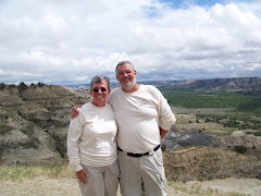
As I sit here writing this final blog I cannot believe the beautiful country that we have seen. We have driven 16,100 miles across Canada and the United States. This is a trip we will never forget and as we look over our photos we will have memories for years to come.
Steve is now planning our next mini adventure to Nova Scotia and eastern Canada. Traveling around the continent is such an awesome experience.
We hope you enjoyed reading our blog and looking at the photos we have taken. Steve and I think we may have taken about 4,000 digital photos over the almost six months.
UNTIL WE TRAVEL AGAIN. We hope you have a blessed Christmas and we look forward to the New Year.
Sunday, December 14, 2008
Final Lap of our Trip
Around November 1st we turned east and started to head home. We made our way through New Mexico, Texas, Oklahoma, Arkanses, Tennessee, and then on to Marietta Georgia for Thanksgiving.
We spend three weeks camping north of Marietta and spent almost 3 weeks with our grand children and chldren. It was an wonderful time to just visit and go to Bounce U with Elise, Gabby, and Travis.
Thanksgiviing was spent with Jeremiah, Annie, Zachary, Melissa, and Travis and his family. Travis cooked a delicious turkey. We had fun playing rock band with Ben and his Melissa. They spend Thanksgiving with her family.
Then it was on to Charleston to see Amanda and Travis. We had a second Thanksgiving with them and their dogs Shadow and Jack.
Then on Wednesday December 3rd, we headed home to Virginia. It was good to get here.
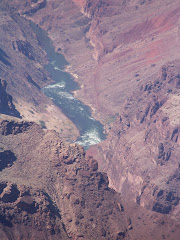
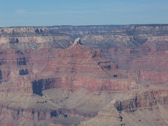
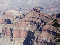
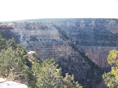
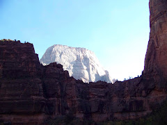
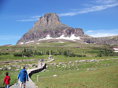
Grand Canyon National Park Arizona
When we left the park of Utah we were trying to digest the beauty. So many memories that will keep us warm this winter.
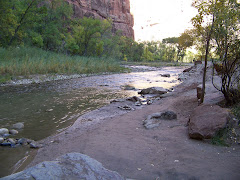
We arrived at the Grand Canyon and spent three nights. The campground was quiet and very pleasant. We rode our bikes, took a hike along the South Rim, and watched a sunset up at the lodge.
This park had many more visitors than the others. We took the shuttle where there was one in order to be able to see everything.
What an awesome place!
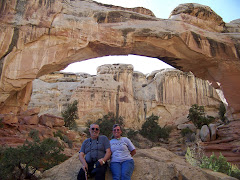
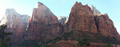
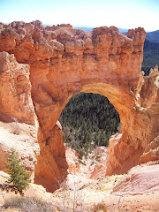
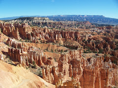
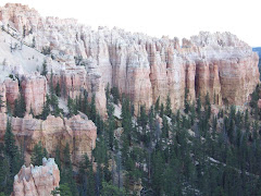
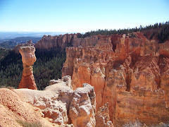
CAPITOL REEF, BRYCE AND ZION NATIONAL PARKS,UTAH
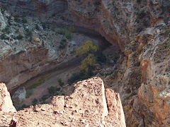
It is amazing that one state can have such beautiful national parks. After Arches we traveled southwest to Capitol Reef National Park. We took a great hike to see the Natural Bridge.
Then onto Bryce where the temperatures dropped aboout 30 degrees. It was so cold we had to close both beds of our camper and sleep on the table that makes into a bed. But once again what beautiful sites we saw.
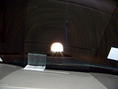
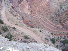
After Bryce we traveled to Zion National Park. The temperature became warm again and made for some great hiking and biking. We entered into Zion from the east side. About a quarter of a mile before the park entrance, there was a sign that said there were size requirements to go through the tunnels. We didn't know if we would make it or not. Well, the park ranger came out and measured the back of the camper and we discovered that it is 93 inches wide and you could not be over 94 inches wide to travel on your own through the tunnels. The tunnel was built in the 1930's for model T's.
What a ride. Thank goodness it was Steve's day to drive. After we got through the 1.1 miles of tunnels the road was a very steep switch back that was not only scary but will be memorable for the rest of our lives.
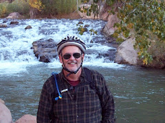
One day we took a bike ride up to Zion Lodge. This road did not allow cars on it; only shuttle buses. We met a couple who were a little older than we were and they were making the ride easily; we couldn't let them show us up so we decided we would ride instead of taking the bus to the lodge. It was a great trip. We met up; with the other couple and talked with them on our ride. They have taken a bike ride of 900miles. I don't think we could go that far!
I think Zion was one of our favorite national parks.
Then onto Bryce where the temperatures dropped aboout 30 degrees. It was so cold we had to close both beds of our camper and sleep on the table that makes into a bed. But once again what beautiful sites we saw.
After Bryce we traveled to Zion National Park. The temperature became warm again and made for some great hiking and biking. We entered into Zion from the east side. About a quarter of a mile before the park entrance, there was a sign that said there were size requirements to go through the tunnels. We didn't know if we would make it or not. Well, the park ranger came out and measured the back of the camper and we discovered that it is 93 inches wide and you could not be over 94 inches wide to travel on your own through the tunnels. The tunnel was built in the 1930's for model T's.
What a ride. Thank goodness it was Steve's day to drive. After we got through the 1.1 miles of tunnels the road was a very steep switch back that was not only scary but will be memorable for the rest of our lives.
One day we took a bike ride up to Zion Lodge. This road did not allow cars on it; only shuttle buses. We met a couple who were a little older than we were and they were making the ride easily; we couldn't let them show us up so we decided we would ride instead of taking the bus to the lodge. It was a great trip. We met up; with the other couple and talked with them on our ride. They have taken a bike ride of 900miles. I don't think we could go that far!
I think Zion was one of our favorite national parks.
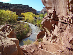
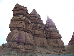
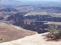
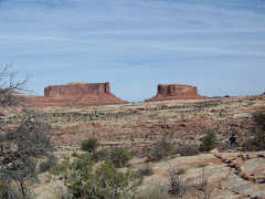
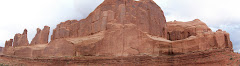
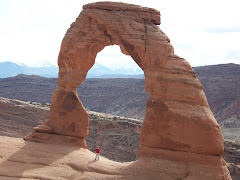
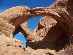
Arches and Canyonlands National Park, Moab Utah
We entered Utah from the east driving into Moab. What a place! If you want to dirt bike, ATV, or hike this is the place to be. We visited Canyonlands National Park and Arches National Park. The colors were brilliant and the sites incredible!
We also took a night time boat ride on the Colorado River. It started out with a bbque dinner and then the boat ride along the river. There was narration and a light show. It was so much fun!
We took a ride around the La Sal Mountains and went to the Red Cliff Lodge for wine tasting from the Castle Creek Winery.
Moab and the surrounding area has been popular in many movies with John Wayne and other famous actors. Geronimo was one of the movies.
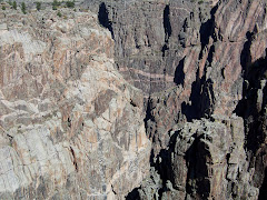
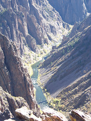
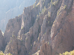
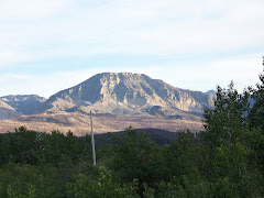
Black Canyon on the Gunnison National Park
After we left Colorado Springs we traveled west to Black Canyon on the Gunnison National Park. The weather was warm and the canyon was unbelievable. We hiked on the various trails and saw a quiet beauty that is hard to put into words.
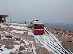
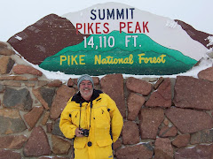
Pikes Peak Colorado
We had to get our winter coats out because we were going to the top of Pike's Peak. The weather there was 6 degrees and snowing. We took the cog railroad to the top. It was a beautiful trip. When we got to the peak the air was very thin. Pike's Peak is 14,110 feet above sea level. We were a little queasy getting of the cog train; but the homemade donuts in the restaurant helped to settle us down. At first it was cloudy but then it started to clear a little. What an awesome day we had.
Monday, October 13, 2008
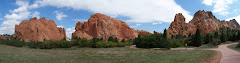
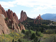
COLORADO SPRINGS, COLORADO
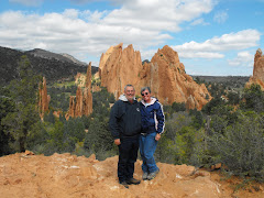
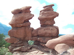
We went to Garden of the Gods which is a beautiful and free park to visit. There are huge red rocks that jut out of the earth. What a marvelous place! We hiked around the central part of the park on a nice paved walkway. Then we went and hiked to two rocks called “Siamese Twins”. They were really neat.
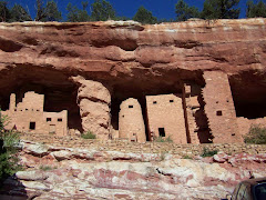
Then we went to Manitou Springs which has cliff dwellings of the Pueblo Indians. These dwellings were acquired from different areas of New Mexico and Southern Colorado and brought here in the early 1900’s. Native Americans lived in these dwellings until 1984. We walked inside the cliff dwellings and saw how small they were. Four families were housed in four rooms of the dwellings.
Then we went to Manitou Springs which has cliff dwellings of the Pueblo Indians. These dwellings were acquired from different areas of New Mexico and Southern Colorado and brought here in the early 1900’s. Native Americans lived in these dwellings until 1984. We walked inside the cliff dwellings and saw how small they were. Four families were housed in four rooms of the dwellings.
SIDNEY, NEBRASKA
We stopped here in Sidney because they were predicting a bad storm. Sidney also is where Cabela’s the world largest sport store headquarters is located. They even have a campground which was very nice. It was very cold and windy for the first two nights and then rainy and windy for the last. We left on Sunday for Colorado Springs.
LAKE MINITARE, NEBRASKA
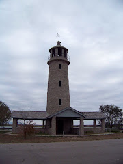
Next we went to Nebraska and Lake Minitare State Park. This lake is known for migrating waterfowl. We were going to go kayaking and see what birds we could; however, when we got up the next morning it was 26 degrees and the wind was blowing at about 25 mph gusts. We decided to take a walk along the lake instead. We did not see any water fowl but we did see the only lighthouse in Nebraska. The CCC built the dam for this lake and when they were done they had time on their hands so they build the lighthouse. We were able to walk up to the top.
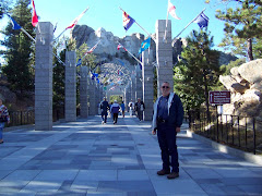
MT. RUSHMORE SOUTH DAKOTA
What a wonderful monument to four wonderful presidents. It was breathtaking to see. After we visited Crazy Horse Memorial, we took the camper and checked in at Custer State Park in Custer, South Dakota. We then went on this 20 miles mountain road to Mt. Rushmore. The road was fantastic on its own. When we were about 5 miles from the monument, we went around a bend and you could see Mt. Rushmore. There were also 3 tunnels that we had to go through and luckily the kayaks made it through.
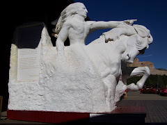
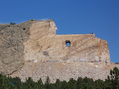
CRAZY HORSE MEMORIAL
We went to the Crazy Horse Memorial which is in the process being built. It is amazing to see and we watched a video that shows how they blast away the rock. The family of the sculptor is carrying on his work. There is his wife and 10 children, all of whom help out with the Visitor’s Center, Museum, and Gift Shop and the ones who are doing the sculpting. Entrance fees are what supports this endeavor. The family will accept gifts of any kind; but will not take any money from the Federal or State Governments…
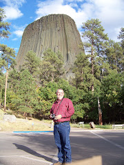
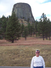
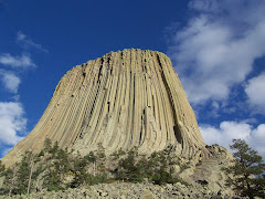
DEVIL'S TOWER WYOMING
We stopped at Devil’s Tower on our way to South Dakota. Some of you remember “Close Encounters of the Third Kind”. It was filmed here. It was amazing to see in person!
POWDER RIVER PASS WYOMING
October 6, 2008
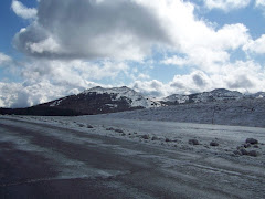
We stayed an extra two days for Precious and she got over her queasy stomach. Sunday afternoon we had a storm with hail and rain. The hail wasn’t very big and did not cause any damage. On our way out of Wyoming we traveled through Powder River Pass at an elevation of 9666 ft. The pass was open but there was snow. It was so beautiful that we stopped and made snowballs. There was even a snow plow clearing the side of the road. How awesome!
We stayed an extra two days for Precious and she got over her queasy stomach. Sunday afternoon we had a storm with hail and rain. The hail wasn’t very big and did not cause any damage. On our way out of Wyoming we traveled through Powder River Pass at an elevation of 9666 ft. The pass was open but there was snow. It was so beautiful that we stopped and made snowballs. There was even a snow plow clearing the side of the road. How awesome!
Saturday, October 4, 2008
Saturday October 4, 2008
We are staying in Thermopolis for a couple extra days because Precious is not feeling well again. Something she ate I am sure. We will leave on Monday for Devil's Tower. While here we are catching up on cleaning and organizing and resting.
Until we meet again...
Until we meet again...
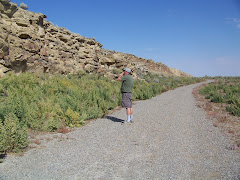
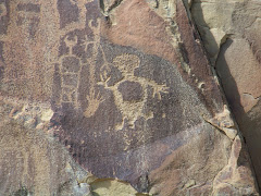
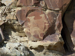
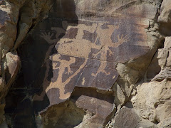
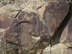
Legend Rock Petroglyphs Thermopolis Wyoming
Yesterday we took a ride outside of Thermopolis to Legend Rock. There were saw petroglyphs which are images that have been "pecked" or "incised" into a rock surface. Who made them? It might have been done as long as 11,200 years ago by Native Americans. Some petroglyhs are easily identified as animals while others are more difficult to identify.
They were really amazing to photograph.
They were really amazing to photograph.
Thursday, October 2, 2008
THERMOPOLIS, WYOMING
Today we left Grand Teton National Park and headed to Thermopolis, Wyoming. On the way we saw a herd of Pronghorn Antelope. We drove through Wind River Canyon. We are at Eagle RV Park that is beautiful and comfortable. Tomorrow on to Hot Springs….
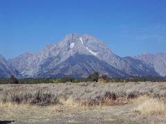
GRAND TETON NATIONAL PARK, WYOMING
On Tuesday we left Yellowstone and traveled to Grand Teton National Park. You left one park and entered the other at the Northern entrance.
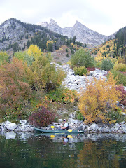
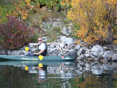
Once again what a beautiful National Park! After we set up camp at Signal Mountain Campground, we drove to Moose Junction stopping at many beautiful spots. We went down around Jenny Lake and saw Sting Lake and decided to go kayaking the next day. You have to obtain passes in order to go on the lakes. We took hundreds of pictures and was amazed at how high the Grand Tetons are. In geological years they are considered teenagers.
One of the mountains we saw was Mt. Moran which is 12,605 ft high. On the peak you can see brown sandstone. The scientists know that there is a layer of sandstone 24,000 feet below the earth that was once connected to Mt. Moran. How awesome!
We drove to the summit of Signal Mountain for sunset. Signal Mountain is 7593 ft high. The sunset was beautiful.
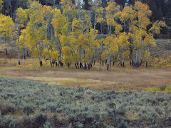
On Wednesday we went to String Lake and then portaged our kayaks for .1 of a mile to Leigh Lake. We then went to the base of Mount Moran and touched the rocks there. As we were on our way to the mountain there were dark clouds coming from behind the mountain. We turned and headed back when it started to thunder. I did not know we could paddle that fast. As we rounded one of the points we saw a bolt of lighting. We decided to get out on the shore and wait out the storm. It rained for just a few minutes and there was no more thunder or lighting and we headed back towards home. We portaged back to String Lake and just enjoyed the beauty of the autumn colors and the beautiful landscape.
On the way back to the camp we went by Jenny Lake and there was a bear eating an elk. I was able to get close enough to snap pictures through the trees. Wow!!
Once again what a beautiful National Park! After we set up camp at Signal Mountain Campground, we drove to Moose Junction stopping at many beautiful spots. We went down around Jenny Lake and saw Sting Lake and decided to go kayaking the next day. You have to obtain passes in order to go on the lakes. We took hundreds of pictures and was amazed at how high the Grand Tetons are. In geological years they are considered teenagers.
One of the mountains we saw was Mt. Moran which is 12,605 ft high. On the peak you can see brown sandstone. The scientists know that there is a layer of sandstone 24,000 feet below the earth that was once connected to Mt. Moran. How awesome!
We drove to the summit of Signal Mountain for sunset. Signal Mountain is 7593 ft high. The sunset was beautiful.
On Wednesday we went to String Lake and then portaged our kayaks for .1 of a mile to Leigh Lake. We then went to the base of Mount Moran and touched the rocks there. As we were on our way to the mountain there were dark clouds coming from behind the mountain. We turned and headed back when it started to thunder. I did not know we could paddle that fast. As we rounded one of the points we saw a bolt of lighting. We decided to get out on the shore and wait out the storm. It rained for just a few minutes and there was no more thunder or lighting and we headed back towards home. We portaged back to String Lake and just enjoyed the beauty of the autumn colors and the beautiful landscape.
On the way back to the camp we went by Jenny Lake and there was a bear eating an elk. I was able to get close enough to snap pictures through the trees. Wow!!
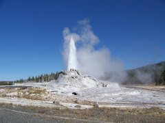
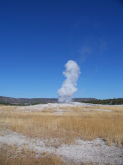
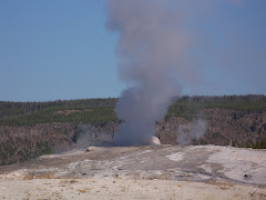
YELLOWSTONE NATIONAL PARK, WYOMING
In a word WOW! We arrived at Yellowstone on Thursday Sept. 25th for four nights. We stayed at the Madison Junction Campground. The first evening we walked down to the Madison River and watched some fly fisherman at work. You can only fly fish and catch and release at Yellowstone.
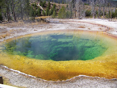
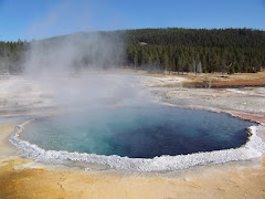
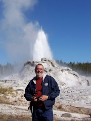
On Friday we went to Old Faithful and waited for the geyser to erupt. I know that we have all been taught about Old Faithful; however, being there and watching it was awesome! It erupts about every 90 minutes give or take 10 minutes. For those who don’t remember their history/science lesson: Surface water seeps underground, is heated by a deep source of magma, and rises as superheated water. Geysers occur when underground constrictions increase the pressure of the water until if finally erupts. Hot springs have no constrictions, so water rises, cools, and sinks. The small amount of water in fumaroles flashes into steam before reaching the surface. Mudpots are acidic hot springs with limited water. The acid and microorganisms decompose surrounding rock into clay and mud.
That being said it was fascinating watching different geysers, hot springs, fumaroles, and mud pots do their thing. We spent the over 4 hours at the Old Faithful area watching different geysers and hot springs. Our favorite was Castle Geyser. It went off for 20 minutes and went as high as 75 feet into the air. We had to wait almost an hour to see it but it was well worth the wait.
For the rest of the day we went to view different geyser basins. On one of the hikes we just crossed a bridge and three huge buffalo came charging down the river. We were not sure which way they were going; but luckily they went the other way running up a hill. Whew!!!
On Saturday we drove to Norris Geyser and then onto Mammoth Hot Springs in the North. We stopped at one place where the Obsidian Cliffs were. We saw large rocks with obsidian in them. Obsidian is a volcanic glass used for projectile points and cutting tools, was traded across North America by American Indians.
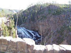
We passed through Mammoth Hot Springs and went to Tower-Roosevelt. We stopped and viewed Urdine Falls and then drove on a 6 miles dirt road, Blacktail Plateau Drive, in hopes of seeing wild game. No luck, but the drive was beautiful.
We then headed back to camp and decided we had to stay another night. You cannot see everything in Yellowstone in three days. We were able to get another night of camping and would leave on Tuesday morning.
On Sunday we drove to the Northeast entrance through Lamar Valley. We saw two herds of buffalo and pronghorn antelope. They were beautiful. We watched for quite a while and then we spotted two coyotes. They were not interested in the antelope, thank goodness.
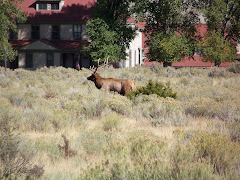
On Monday we drove to Canyon Village and back toward Tower Roosevelt. Such beautiful area and the trees are turning. We also passed back through Mammoth Hot Springs and saw a bull elk and his harem. His antlers, rack, was probably 3 or more feet apart.
On Tuesday on our way out we drove by the West Thumb of Yellowstone Lake and headed south to the Grand Tetons. Another beautiful drive.
We did not see everything there was to see. In four days we drove 400 miles and never left the park. Needless to say we need to go back. We did not take any of the hikes available because there was not enough time. Also the weather was unusually warm so there were not as many sightings of animals as there should have been.
On Friday we went to Old Faithful and waited for the geyser to erupt. I know that we have all been taught about Old Faithful; however, being there and watching it was awesome! It erupts about every 90 minutes give or take 10 minutes. For those who don’t remember their history/science lesson: Surface water seeps underground, is heated by a deep source of magma, and rises as superheated water. Geysers occur when underground constrictions increase the pressure of the water until if finally erupts. Hot springs have no constrictions, so water rises, cools, and sinks. The small amount of water in fumaroles flashes into steam before reaching the surface. Mudpots are acidic hot springs with limited water. The acid and microorganisms decompose surrounding rock into clay and mud.
That being said it was fascinating watching different geysers, hot springs, fumaroles, and mud pots do their thing. We spent the over 4 hours at the Old Faithful area watching different geysers and hot springs. Our favorite was Castle Geyser. It went off for 20 minutes and went as high as 75 feet into the air. We had to wait almost an hour to see it but it was well worth the wait.
For the rest of the day we went to view different geyser basins. On one of the hikes we just crossed a bridge and three huge buffalo came charging down the river. We were not sure which way they were going; but luckily they went the other way running up a hill. Whew!!!
On Saturday we drove to Norris Geyser and then onto Mammoth Hot Springs in the North. We stopped at one place where the Obsidian Cliffs were. We saw large rocks with obsidian in them. Obsidian is a volcanic glass used for projectile points and cutting tools, was traded across North America by American Indians.
We passed through Mammoth Hot Springs and went to Tower-Roosevelt. We stopped and viewed Urdine Falls and then drove on a 6 miles dirt road, Blacktail Plateau Drive, in hopes of seeing wild game. No luck, but the drive was beautiful.
We then headed back to camp and decided we had to stay another night. You cannot see everything in Yellowstone in three days. We were able to get another night of camping and would leave on Tuesday morning.
On Sunday we drove to the Northeast entrance through Lamar Valley. We saw two herds of buffalo and pronghorn antelope. They were beautiful. We watched for quite a while and then we spotted two coyotes. They were not interested in the antelope, thank goodness.
On Monday we drove to Canyon Village and back toward Tower Roosevelt. Such beautiful area and the trees are turning. We also passed back through Mammoth Hot Springs and saw a bull elk and his harem. His antlers, rack, was probably 3 or more feet apart.
On Tuesday on our way out we drove by the West Thumb of Yellowstone Lake and headed south to the Grand Tetons. Another beautiful drive.
We did not see everything there was to see. In four days we drove 400 miles and never left the park. Needless to say we need to go back. We did not take any of the hikes available because there was not enough time. Also the weather was unusually warm so there were not as many sightings of animals as there should have been.
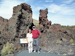
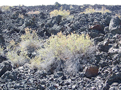
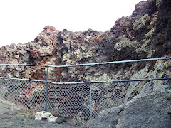
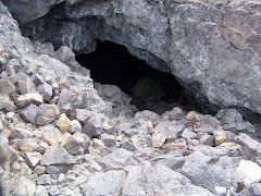
CRATERS OF THE MOON, ARCO IDAHO
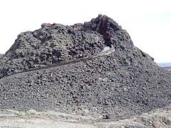
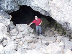
On to Craters of the Moon National Monument and Preserve--Craters of the Moon National Monument is located in the cradle of Idaho's Snake River Plain. Beginning 15,000 years ago, molten basalt erupted from fissures in the earth's crust creating this landscape of black and raw lava flows that undulates like a quiet sea. Cinder cones, craters, and myriad volcanic formations line the fissures, or Great Rift, for some sixty miles from north to south, and rise above a surface swirling with frozen eddies and cascading blocks of lava foam.
There were so many things to see. One was a chance to climb up the side of a small volcano and look into it. Amazing! Another was into two different caves made of lava rocks. It was very cool inside and dark! Just look at the pictures!
There were so many things to see. One was a chance to climb up the side of a small volcano and look into it. Amazing! Another was into two different caves made of lava rocks. It was very cool inside and dark! Just look at the pictures!
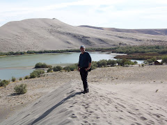
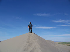
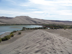
BRUNEAU DUNES STATE PARK, MOUNTAIN HOME, IDAHO
From Oregon we went to Bruneau Dunes State Park, south of Mountain Home Idaho. There are sand dunes here next to two lakes. Here is why: Bruneau Dunes started to form 11,000 years ago after the tremendous Bonneville Flood. BD is the tallest single sand dune structure in North America. Ideal conditions existed here for sand dune formation. 1) a circular basin carved by the Snake River which forms a natural trap to cat h wind born sand 2) a supply of sand coming from ancient sediment laid down in the Snake River plateau 3) a wind blowing at least 10 miles per hour to transport the sand. The dune is created and maintained by long term wind patterns. The wind comes from two prevailing directions approximately 180 degrees apart. The opposing winds keep the dunes in place.
We climbed up the dunes and walked along the top of one of them. It was so much fun
We climbed up the dunes and walked along the top of one of them. It was so much fun
LA PINES, OREGON on the Deschustes River and CRATER LAKE NATIONAL PARK
September 17-21, 2008
We decided we needed a vacation from our retirement adventure so we went to La Pines, Oregon about 25 miles south of Bend Oregon to La Pines State Park. We stayed for 5 nights. On the day of our arrival we met Frank and Marilyn who were head of a Good Sam RV group. They were rally masters for a work session at the park. About 7 other RVers joined them for this event. Frank invited us over after dinner to play Mexican Train. This is a game with dominoes, one we had never hearad of, that was a lot of fun to play.
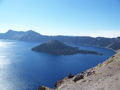
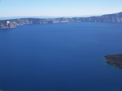
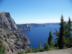
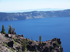
On the 18th we went to Crater Lake National Park. This was about 60 miles southeast of La Pines SP. When we arrived at the park the first lookout was over the lake with a perfect view. The water was so blue and the view of Wizard Island was spectacular! We spent most of the day driving around the lake and seeing different views. By late afternoon the view were getting hazy because of three fires burning to the north of Crater Lake.
La Pines State Park is on the Deschutes River. There is supposed to be great trout fishing there; however, the river was difficult to get down the banking to. We decided to drive about 15 miles from the campground and went to Twin Lakes to kayak and fly fish.
Steve taught me how to fly fish. I was not too lucky but on the first day Steve caught two rainbow trout and the next time we went he caught two more. We ate the first two and then froze the others for later.
The weather was cool and the water was too. But the kayaking and the fishing were great!
We decided we needed a vacation from our retirement adventure so we went to La Pines, Oregon about 25 miles south of Bend Oregon to La Pines State Park. We stayed for 5 nights. On the day of our arrival we met Frank and Marilyn who were head of a Good Sam RV group. They were rally masters for a work session at the park. About 7 other RVers joined them for this event. Frank invited us over after dinner to play Mexican Train. This is a game with dominoes, one we had never hearad of, that was a lot of fun to play.
On the 18th we went to Crater Lake National Park. This was about 60 miles southeast of La Pines SP. When we arrived at the park the first lookout was over the lake with a perfect view. The water was so blue and the view of Wizard Island was spectacular! We spent most of the day driving around the lake and seeing different views. By late afternoon the view were getting hazy because of three fires burning to the north of Crater Lake.
La Pines State Park is on the Deschutes River. There is supposed to be great trout fishing there; however, the river was difficult to get down the banking to. We decided to drive about 15 miles from the campground and went to Twin Lakes to kayak and fly fish.
Steve taught me how to fly fish. I was not too lucky but on the first day Steve caught two rainbow trout and the next time we went he caught two more. We ate the first two and then froze the others for later.
The weather was cool and the water was too. But the kayaking and the fishing were great!
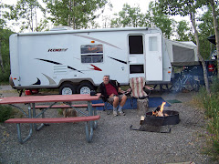
CULVER KOA AND TRUCK REPAIRS
Here I sit in the laundry at a KOA. We didn’t plan to stay here for two days, but the truck had a different idea. As we were climbing up Blue Box Pass a truck went by us and we thought that it was making a terrible noise. We thought he blew a tire; however, as we continued up the steep road, we discovered it was US making that noise. There was a rest stop at the summit. We stopped, took off the bikes, and looked up and down the truck. We could not see any problems; so we called Travis, our handy dandy repairman. Steve did all the things Travis said to do and couldn’t find any major problems.
After lunch we set out again on our way. Travis found us a Ford garage in Madras, OR, that was about 45 miles away. The noise continued when we accelerated to go up the hills and as there were many, we just held our breath. I called the Ford garage to inform them of our arrival. The serviceman was very nice and sent a mechanic out right away to ride with Steve. The diagnosis was a disintegrating catalytic converter. We are so lucky that we have 2! The parts needed to be ordered so we traveled 6 miles to the KOA for the night. We took the truck in the next day and the repairs were made. Hopefully all will go well and we will continue on our adventure.
On our way to Culver, OR, we passed by Mt. Hood and Mt. Jefferson. They are snow covered as they are about 12,000 or so feet high. The view was hazy because the farmers in the area are burning their fields after the summer crops have been harvested. We saw a tractor pulling this contraption, fed by propane, with fire coming out and burning the land. That is a job I wouldn’t volunteer for…
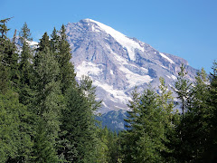
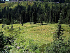
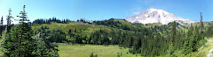
MT. RAINIER WASHINGTON
On Saturday we traveled to Mossyrock, WA, and stayed at a private campground. We had a site on Lake Mayfield. The site was really nice and quiet.
On Sunday we traveled, along with thousands of others, to Mt. Rainier. After entering the park we stopped at Klautz Creek. Then onto Longmire Museum which had displays about the area. We took a hike through the forest and saw three mineral springs.
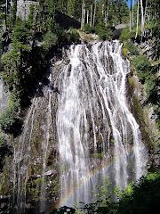
After the hike we continued on to Paradise about 19 miles away. We stopped, ate a picnic lunch and then hiked down to Narada Falls where the river flows down the 168 ft. rocks. The falls were so beautiful and you could see a rainbow that was reflected from the rocks. Gorgeous! Then on to Paradise where there is a hotel and visitor center. Little did we know that hundreds of other people had the same idea as us. When we got to the Paradise area, the main parking lot was full and the overflow was just as full. We drove around again and decided to just drive through the area. We stopped along the road at different intervals to take pictures of Mt. Rainier. It is 14,467 ft tall. Also the meadow around Mt. Rainier was beautiful. The leaves are slowly starting to turn and Sunday was a warm, beautiful day. There are still a few types of flowers blooming.
On Sunday we traveled, along with thousands of others, to Mt. Rainier. After entering the park we stopped at Klautz Creek. Then onto Longmire Museum which had displays about the area. We took a hike through the forest and saw three mineral springs.
After the hike we continued on to Paradise about 19 miles away. We stopped, ate a picnic lunch and then hiked down to Narada Falls where the river flows down the 168 ft. rocks. The falls were so beautiful and you could see a rainbow that was reflected from the rocks. Gorgeous! Then on to Paradise where there is a hotel and visitor center. Little did we know that hundreds of other people had the same idea as us. When we got to the Paradise area, the main parking lot was full and the overflow was just as full. We drove around again and decided to just drive through the area. We stopped along the road at different intervals to take pictures of Mt. Rainier. It is 14,467 ft tall. Also the meadow around Mt. Rainier was beautiful. The leaves are slowly starting to turn and Sunday was a warm, beautiful day. There are still a few types of flowers blooming.
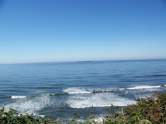
PACIFIC COAST HIGHWAY ROUTE 101
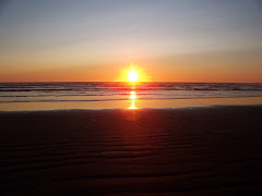
After we left Hoh Rain Forest we headed south on 101 along the coast. 101 is a highway that makes a loop around Olympic National Park and then goes down along the coast of Washington and the coast of Oregon. As we made the turn along the coast we got a breathtaking view of the Pacific Ocean. It is gorgeous. We continued driving until we reached Pacific Beach State Park. We got a site on the ocean for two nights. As we were setting up a fog rolled in and you couldn’t tell where the ocean was and as it was low tide you could barely hear it. Around 6:30 p.m. the fog lifted and we took a walk on the beach. It was very cold and windy but there was an absolutely gorgeous sunset. We walked a mile or two and watched the birds and seagulls.
On Saturday we drove into Ocean Shore, WA and had lunch at a nice the Homesport Restaurant. The food was delicious. We had to get a bulb for the truck because the left turn signal was burnt out. We went to ACE Hardware that also had a Radio Shack inside. You could buy anything from work clothing to plumbing to souvenirs to wedding gifts. It was like a department store. On the way out of Ocean Shores we stopped at a casino and won a $20.00. Steve had a lucky machine….
On Saturday we drove into Ocean Shore, WA and had lunch at a nice the Homesport Restaurant. The food was delicious. We had to get a bulb for the truck because the left turn signal was burnt out. We went to ACE Hardware that also had a Radio Shack inside. You could buy anything from work clothing to plumbing to souvenirs to wedding gifts. It was like a department store. On the way out of Ocean Shores we stopped at a casino and won a $20.00. Steve had a lucky machine….
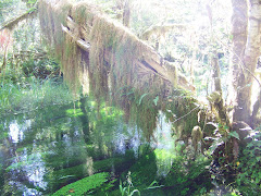
OLYMPIC NATIONAL PARK--HOH RAIN FOREST
Friday we drove on 101 West to the Hoh Rain Forest. This is still part of Olympic National Park. We went to the campground first to set up. The campground was on the Hoh River. We had a nice site not too far from the river. After setting up we took a hike on two trails: the Trail of the Shadows and Spruce Trail. Both were interpretive trails and described the rain forest here in the Northwest.
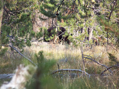
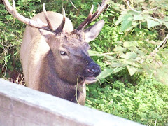
On the way to Spruce Trail we saw an elk eating by the stream. He was beautiful. The signs all around the area said to say 100 feet from the elk because they have been charging visitors. After our hike we went back to the truck and on our way there were two elk sparring with each other. They make a high squeaky noise which was surprising to us because of their size. They fought with their antlers and the sound you heard was like sticks hitting each other. We watched them for awhile and then went back to the camper. Later on after supper, we saw them again and there was a third elk that joined them. They were just eating grass around the park. Very exciting!
On the way to Spruce Trail we saw an elk eating by the stream. He was beautiful. The signs all around the area said to say 100 feet from the elk because they have been charging visitors. After our hike we went back to the truck and on our way there were two elk sparring with each other. They make a high squeaky noise which was surprising to us because of their size. They fought with their antlers and the sound you heard was like sticks hitting each other. We watched them for awhile and then went back to the camper. Later on after supper, we saw them again and there was a third elk that joined them. They were just eating grass around the park. Very exciting!
OLYMPIC NATIONAL PARK, WASHINGTON
We arrived at Elwah Dam RV Park on Sunday to stay for 3 nights.
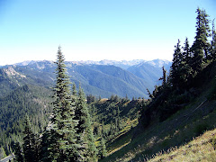
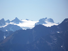
Our first trip in the National Park was to Hurrican Ridge. The visitor's center offers an outstanding view of several glaciers, see photos. We hiked another 1/2 mile about 200 feet in elevation and got a fantastic view of the north and east of the park. We could see as far as Victoria, Vancouver, Canada.
We also saw a mule deer who was not afraid to pose for us.
The next day we took a ride to Sol Duc Hot Springs in Olympic National Park. On the way we stopped and hiked to Marymere Falls.
It was a beautiful ride to the Sol Duc Resort where you have to pay to use the natural (?) hot springs. The resort was built in 1912 around the hot springs. We went into the resort and saw the springs. They have been cemented in and painted blue to make it look more like a modern spa. However, the water is from the hot springs and they are not treated in any way with chemicals. We decided to go on the hike to the Sol Duc Falls which were awesome. The hike was about 1.5 miles through the forests which are outstanding.
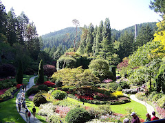
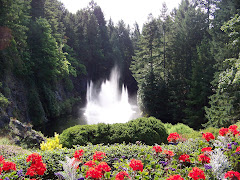
On Tuesday, we took the 8:15 a.m. ferry from Port Angeles, WA to Victoria, Vancouver, Canada. The ferry ride was about 55 minutes long and we bought a tour ride to Butchart Gardens. This is one of the most beautiful gardens. Originally the area was a limestone quarry, but after the resources were exhausted, Mrs. Butchart wanted to make the area look nice so she hired people to landscape the area. There is a rose garden section, Japanese Garden, Sunken garden area, and an Italian garden. The weather on Tuesday was glorious which only enhanced the beauty of this garden.
After the garden tour we went back into Victoria and had lunch as a restaurant overlooking the water. Then we went to the British Columbia Museum. The exhibits there were wonderful and explained the history of North American and particularly British Columbia. There was a Mammoth exhibit that was excellent. We spent two hours at the museum before returning to the dock to pick up the ferry at 6:10 to return to Port Angeles. What a wonderful day!
Our first trip in the National Park was to Hurrican Ridge. The visitor's center offers an outstanding view of several glaciers, see photos. We hiked another 1/2 mile about 200 feet in elevation and got a fantastic view of the north and east of the park. We could see as far as Victoria, Vancouver, Canada.
We also saw a mule deer who was not afraid to pose for us.
The next day we took a ride to Sol Duc Hot Springs in Olympic National Park. On the way we stopped and hiked to Marymere Falls.
It was a beautiful ride to the Sol Duc Resort where you have to pay to use the natural (?) hot springs. The resort was built in 1912 around the hot springs. We went into the resort and saw the springs. They have been cemented in and painted blue to make it look more like a modern spa. However, the water is from the hot springs and they are not treated in any way with chemicals. We decided to go on the hike to the Sol Duc Falls which were awesome. The hike was about 1.5 miles through the forests which are outstanding.
On Tuesday, we took the 8:15 a.m. ferry from Port Angeles, WA to Victoria, Vancouver, Canada. The ferry ride was about 55 minutes long and we bought a tour ride to Butchart Gardens. This is one of the most beautiful gardens. Originally the area was a limestone quarry, but after the resources were exhausted, Mrs. Butchart wanted to make the area look nice so she hired people to landscape the area. There is a rose garden section, Japanese Garden, Sunken garden area, and an Italian garden. The weather on Tuesday was glorious which only enhanced the beauty of this garden.
After the garden tour we went back into Victoria and had lunch as a restaurant overlooking the water. Then we went to the British Columbia Museum. The exhibits there were wonderful and explained the history of North American and particularly British Columbia. There was a Mammoth exhibit that was excellent. We spent two hours at the museum before returning to the dock to pick up the ferry at 6:10 to return to Port Angeles. What a wonderful day!
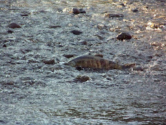
DOSEWALLIPS STATE PARK, WASHINGTON
We stopped at Dosewallips SP in Washington across the Puget Sound from Seattle for one night. A beautiful park where the chum salmon were swimming upstream on the Dosewallip River to spawn. The salmon were about 2 1/2 feet long and weighed quite a bit. The river was very shallow so you could see the salmon very easily.
We also watched the eagles flying up and down stream looking for a snack! They were beautiful! We had a nice site not too far from the river.
We people on the east coast always hear about the salmon swimming upstream; boy was it amazing to watch!
We also watched the eagles flying up and down stream looking for a snack! They were beautiful! We had a nice site not too far from the river.
We people on the east coast always hear about the salmon swimming upstream; boy was it amazing to watch!
Friday, September 5, 2008
EVERETT, WASHINGTON
I am sitting here in Everett and, Washington just north of Seattle. We are on our way to Olympic National Park. We are catching up on blogging and laundry. We washed the camper yesterday and will wash the truck today.
We will leave on Saturday to drive to Dosewallpis State Park still on our way to Olympic National Park.
Today, Friday, we drove to Elliot Point on the Puget Sound and watched the ferry to Whidbey Island load and unload people, motorcycles, trucks and car. The ferry holds 100 cars, 27 motorcycle, and lots of people.
We had supper at Ivar's clam shack. It was delicious. Steve had oysters and chips and salmon chowder. I had fish and chips. Yum, Yum!
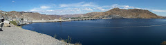
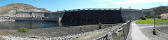
GRAND COULEE DAM, WASHINGTON
Sept. 3rd.
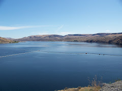
Today we went and saw the Grand Coulee Dam, Washington. Construction on Grand Coulee Dam was started in 1933. Its construction was authorized during Franklin Roosevelt’s time as president. The dam is nearly one mile across the top. Grand Coulee is one of the largest concrete structures in the world, containing almost 12 million cubic years of concrete. The dam has three important functions: irrigation, power production, and flood control. Electricity energy was not the first function when it was created; however, it is now the most important job. When they built the dam Lake Roosevelt (a reservoir) was created. This lake extends 151 miles upstream to the Canadian border. It has a shoreline of 660 miles.
APPLE, PEACH, AND GRAPES
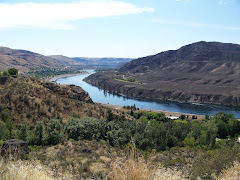
After viewing both sides of the dam we drove on a scenic byway on our way to Alta Lake State Park. This drive was through the Coleville Nation Indian Reservation and along the Columbia River and Okanagan River. The valley is filled with apple and peach orchards and vineyards. What a beautiful site to see the green trees and vines along with the tall coulees of the area.
We were driving through the Coulee Corridor there were coulees and canyons throughout the landscape. This area was shaped by many natural forces, mountain building, subsidence to seas, volcanic activity, and one of the greatest ice age floods on earth. Two principal agents of landscape change standout, fire and ice. Millions of years ago, multiple lava floods of basalt from volcanic activity covered the region to depths of more than 1,000 feet. The vertical coulee walls show layers of up to seven volcanic flows occurring over the Miocene period. Subsequent catastrophic Ice Age floods sweeping down from Lake Missoula during the Pleistocene epoch carved and scoured the land, leaving behind a strange array of basalt rock formations, cliffs, caves, coulees, and channeled scablands.
Alta Lake State Park was small and sloping so we traveled further south to Chelan, Washington, and stayed at a town park that was very nice. We decided to stay in Everett, Washington, on our way to Olympic National Park.
Today we went and saw the Grand Coulee Dam, Washington. Construction on Grand Coulee Dam was started in 1933. Its construction was authorized during Franklin Roosevelt’s time as president. The dam is nearly one mile across the top. Grand Coulee is one of the largest concrete structures in the world, containing almost 12 million cubic years of concrete. The dam has three important functions: irrigation, power production, and flood control. Electricity energy was not the first function when it was created; however, it is now the most important job. When they built the dam Lake Roosevelt (a reservoir) was created. This lake extends 151 miles upstream to the Canadian border. It has a shoreline of 660 miles.
APPLE, PEACH, AND GRAPES
After viewing both sides of the dam we drove on a scenic byway on our way to Alta Lake State Park. This drive was through the Coleville Nation Indian Reservation and along the Columbia River and Okanagan River. The valley is filled with apple and peach orchards and vineyards. What a beautiful site to see the green trees and vines along with the tall coulees of the area.
We were driving through the Coulee Corridor there were coulees and canyons throughout the landscape. This area was shaped by many natural forces, mountain building, subsidence to seas, volcanic activity, and one of the greatest ice age floods on earth. Two principal agents of landscape change standout, fire and ice. Millions of years ago, multiple lava floods of basalt from volcanic activity covered the region to depths of more than 1,000 feet. The vertical coulee walls show layers of up to seven volcanic flows occurring over the Miocene period. Subsequent catastrophic Ice Age floods sweeping down from Lake Missoula during the Pleistocene epoch carved and scoured the land, leaving behind a strange array of basalt rock formations, cliffs, caves, coulees, and channeled scablands.
Alta Lake State Park was small and sloping so we traveled further south to Chelan, Washington, and stayed at a town park that was very nice. We decided to stay in Everett, Washington, on our way to Olympic National Park.
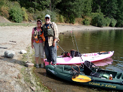
Farrgut State Park, Idaho
We left with the intention of traveling to Grand Coulee Dam, but Steve found a nice lake in northern Idaho to fish for Kokanee Salmon. We stopped in Post Falls, Idaho, and mailed some packages and did some shopping at Wal-Mart. We had to mail some clothes and books to make more room in the camper.
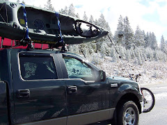
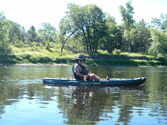
We arrived at Farragut State Park, set up and then went to Spirit Lake about 15 miles west. We put the kayaks in the water and set out to fish. The kayaking was the best yet. The water was still and you could leisurely paddle. To catch kokanee salmon you are supposed to troll. We just paddled and then just moved smoothly in a zigzag pattern to attract the salmon.
I got two 5-inch salmon which were too small and one black crappie. Steve had a bite or two; but no supper. It was a wonderful three hours on a beautiful lake.
IDAHO--Heyburn State Park, Coeur d'Alene
Sept. 1st LABOR DAY
We left Tally Lake and stayed at Jim and Mary's RV Park in Missoula, Montana. This is perhaps the nicest commercial RV park we have ever stayed at.
We left Montana Monday on our way to Idaho. We are in the panhandle of Idaho and it is a beautiful mountainous state. We drove from I-90 down to Heyburn State Park. We drove around Coeur d’Alene Lake in Idaho. This is a very large and gorgeous lake. We saw many vacation homes along the lake. The ride was 47 miles on a very windy and hilly road; but what a view!
We stopped in St. Marie’s and got fishing licenses and night crawlers.
Heyburn State Park was nice but the water was contaminated. We didn’t realize until after we had unhitched the camper. The campground host had drinking water for sale. Thank goodness because our holding tank was almost empty. We stayed for the night and went kayaking and fishing on part of Coeur d’Alene Lake. No bites but a beautiful sunset.
Tally Lake National Forest
On Friday we left to go to Kalispell, Mt, but decided to detour north to Tally Lake. There was a National Forest campground there that drew our attention. We had to drive 9 miles down a gravel road to get there and halfway down we hoped there was a site free. Well, we were lucky and there were sites and we had a great pull thru site for two nights.
After we set up we took a walk down to the lake and Steve got stung by a bee 4 times. We immediately went back to the camper and he gave himself a shot and took two Benadryl. I watched him and prayed we didn’t have to drive 45 minutes to the nearest hospital over which was 9 miles of gravel road! Luckily, he was okay.
The next day we went kayaking on the lake and had a great time. The deepest lake in Montana was surrounded by mountains and trees.
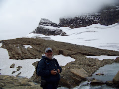
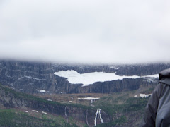
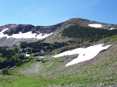
YOU NEED TO GO TO GLACIER NATIONAL PARK
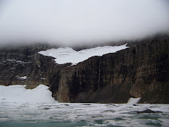
I cannot say enough about the experience we had at Glacier National Park. The ranger explained that each year some of the glaciers are downgraded to snow. There are certain criteria that a glacier must meet to be called a glacier. Last year two glaciers were downgraded.
The ranger said that by 2020 there probably won't be anymore glaciers at the park. So if you want to see glaciers at Glacier National Park, plan your trip. It is really not that expensive and you can camp. There were many tents there and you keep your food in a food storage bin and your car. You will not be sorry about visiting Glacier!
The ranger said that by 2020 there probably won't be anymore glaciers at the park. So if you want to see glaciers at Glacier National Park, plan your trip. It is really not that expensive and you can camp. There were many tents there and you keep your food in a food storage bin and your car. You will not be sorry about visiting Glacier!
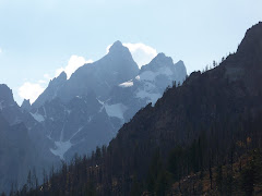
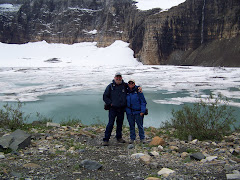
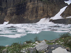
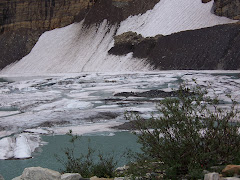
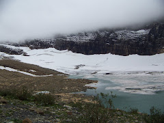
GRINNELL GLACIER
Grinnell Glacier
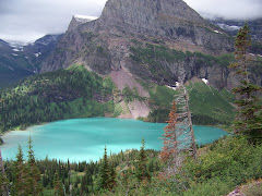
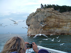
On Thursday it was still cloudy and cold; however, we were taking a hike to Grinnell Glacier. We had to drive outside the park, North, to Many Glaciers and took a boat across Swiftcurrent Lake and then Lake Josephine. We took a ranger-led hike to Grinnell Glacier. The 4 mile trail up to the glacier was truly worth the hike. It was strenous as we gained 1600 feet in elelvation over the four miles. Along the way we saw Grinnell Lake, Grinnell Waterfalls, big horn sheep,and beautiful flowers. We ate lunch before we walked the last half mile straight up to view the glacier.
Words cannot describe the view. Hopefully the pictures can!
We were on our own to get back to the boat dock and took a few hours to get there. The hike down was almost as strenous as the hike up. We were really tired at night; but it was a hike I will never forget.
On the boat back across Lake Josephine, the captain pointed out a grizzly bear on the mountain side. It was far up but you could still see it. That is the only bear we saw in Glacier.
GLACIER NATIONAL PARK
Aug. 23th
We left Great Falls, Montana and started our drive to Glacier—163 miles. It was an awesome ride. It was my turn to drive and when we arrived in Browning, MT we stopped for gas along with the rest of the world. Then we set out for the last 31 miles to Glacier which was truly a mountainous road. We went to 5950 ft in elevation and then down to 4500. It was fun going down! We arrived at Glacier and went into the park. With Steve’s Senior Access Pass we did not have to pay an entrance fee and camping is half price!
We stayed on the East side of Glacier at St Mary’s Campground ½ mile from the entrance. They say "Lccation, location, location is everything". We selected a wonderful site with snow on the mountains as our view. Breathtaking! One is not allowed to leave anything out at the park because of bears. We took out the camp stove, cooked, and then put it back in the truck. We slept with the bed down, but when we left for the day we put it back up to make sure Precious would be safe.
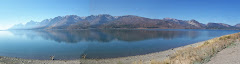
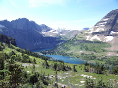
We took a ride around part of the park and drove along St. Mary’s Lake. It is a 9.9 mile lake and is so blue! The Rocky Mountains are so tall that it makes the Appalachian’s look like rolling hills.
24th Aug.
We got up and the temperature was 45-48 outside. Thank goodness for the furnace!
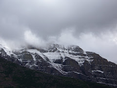
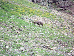
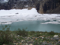
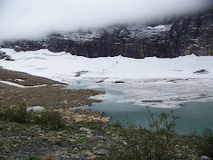
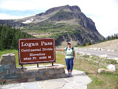
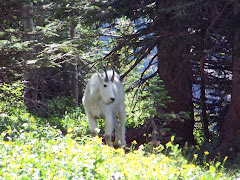
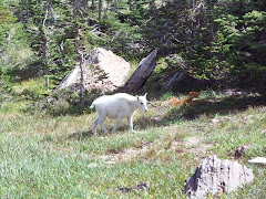
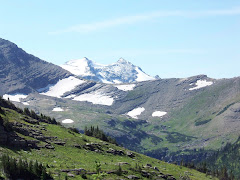
We went to the St. Mary’s Visitor Center and boarded a shuttle. It was a 50 minute ride up to Logan Pass which is 6600 ft in elevation and the top of the Continental Divide. Behind the visitor center at Logan Pass we took a hike to Hidden Lake Overlook. This was partly a boardwalk and partly trail. It was amazing to see the snow on the mountains and then the beautiful flowers. There were also little waterfalls running from the melting snow. Words cannot express the beauty we saw. We saw a Hoary marmot that whistles, a Columbian Ground Squirrel, a golden-mantled ground squirrel and lots of mountain goats. The goats were so funny they practically posed for us. We even saw a baby goat!
Hidden Lake was magnificent with water that was a greenish blue!
We then took another shuttle from Logan Pass to Avalanche Creek. This section of the road was under construction. What a scary ride. This was truly a mountain road where you look down the side of the road into a valley below. The view was spectacular and breathtaking.
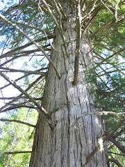
We walked the Trail of the Cedars along Avalanche Creek. There were the biggest cedar trees you have ever seen. This environment was so cool and green. There were a lot of trees that had fallen over because the water in this area is plentiful and the trees do not root very deeply. A strong wind can come through and blow them over.
There was also a gorge glaciers had cut into the rock and water from Avalanche Lake flow into it! Awesome!
Back to the campground for dinner.
On Monday there was a cool breeze and we had to wear a jacket. We had to take Precious to a vet because she had been having issues for 3 days. Outside Glacier is the Blackfeet Reservation. We found a vet who looked at Precious and gave us some medicine help Precious. The doctor said she would be better in a couple of days. It only costs $27.60 for checkup and medicine. We spent the rest of the day relaxing and watching Precious.
The wind in the park was very strong. Storm clouds came up we had to batten down the hatches. The temperature dropped quite a bit. When we went to bed we prayed we wouldn’t blow away.
Tuesday and Wednesday turned out to be very windy and cold. We took a ride and you couldn’t even see the tops of the mountains. We found out that Logan Pass was closed because of winter like weather. We tried to go fishing; but the wind was so strong that we couldn’t even cast the line! Winds with gusted to 60 mph forcing us to keep the camper closed during the day. It quieted down around 7 p.m. and we put the bed back down.
We left Great Falls, Montana and started our drive to Glacier—163 miles. It was an awesome ride. It was my turn to drive and when we arrived in Browning, MT we stopped for gas along with the rest of the world. Then we set out for the last 31 miles to Glacier which was truly a mountainous road. We went to 5950 ft in elevation and then down to 4500. It was fun going down! We arrived at Glacier and went into the park. With Steve’s Senior Access Pass we did not have to pay an entrance fee and camping is half price!
We stayed on the East side of Glacier at St Mary’s Campground ½ mile from the entrance. They say "Lccation, location, location is everything". We selected a wonderful site with snow on the mountains as our view. Breathtaking! One is not allowed to leave anything out at the park because of bears. We took out the camp stove, cooked, and then put it back in the truck. We slept with the bed down, but when we left for the day we put it back up to make sure Precious would be safe.
We took a ride around part of the park and drove along St. Mary’s Lake. It is a 9.9 mile lake and is so blue! The Rocky Mountains are so tall that it makes the Appalachian’s look like rolling hills.
24th Aug.
We got up and the temperature was 45-48 outside. Thank goodness for the furnace!
We went to the St. Mary’s Visitor Center and boarded a shuttle. It was a 50 minute ride up to Logan Pass which is 6600 ft in elevation and the top of the Continental Divide. Behind the visitor center at Logan Pass we took a hike to Hidden Lake Overlook. This was partly a boardwalk and partly trail. It was amazing to see the snow on the mountains and then the beautiful flowers. There were also little waterfalls running from the melting snow. Words cannot express the beauty we saw. We saw a Hoary marmot that whistles, a Columbian Ground Squirrel, a golden-mantled ground squirrel and lots of mountain goats. The goats were so funny they practically posed for us. We even saw a baby goat!
Hidden Lake was magnificent with water that was a greenish blue!
We then took another shuttle from Logan Pass to Avalanche Creek. This section of the road was under construction. What a scary ride. This was truly a mountain road where you look down the side of the road into a valley below. The view was spectacular and breathtaking.
We walked the Trail of the Cedars along Avalanche Creek. There were the biggest cedar trees you have ever seen. This environment was so cool and green. There were a lot of trees that had fallen over because the water in this area is plentiful and the trees do not root very deeply. A strong wind can come through and blow them over.
There was also a gorge glaciers had cut into the rock and water from Avalanche Lake flow into it! Awesome!
Back to the campground for dinner.
On Monday there was a cool breeze and we had to wear a jacket. We had to take Precious to a vet because she had been having issues for 3 days. Outside Glacier is the Blackfeet Reservation. We found a vet who looked at Precious and gave us some medicine help Precious. The doctor said she would be better in a couple of days. It only costs $27.60 for checkup and medicine. We spent the rest of the day relaxing and watching Precious.
The wind in the park was very strong. Storm clouds came up we had to batten down the hatches. The temperature dropped quite a bit. When we went to bed we prayed we wouldn’t blow away.
Tuesday and Wednesday turned out to be very windy and cold. We took a ride and you couldn’t even see the tops of the mountains. We found out that Logan Pass was closed because of winter like weather. We tried to go fishing; but the wind was so strong that we couldn’t even cast the line! Winds with gusted to 60 mph forcing us to keep the camper closed during the day. It quieted down around 7 p.m. and we put the bed back down.
Thursday, August 21, 2008
UNTIL WE MEET AGAIN
Well, we are going to be out of internet for awhile as we go to Glacier National Park. See you on the other side.
GREAT FALLS, MONTANA
We are now at Great Falls, Montana KOA. We are here to finish our preparations to go to Glacier National Park on Saturday. We will finish the laundry tomorrow and get a few groceries on the way out of town Saturday morning.
Today we went on the River Edge Trail along the Missouri River. We biked about 10 miles. Some on asphalt and some on a mountain bike trail. We went down some steep paths and then back up. It was scary and fun. I felt at one time I was flying in the air. We had a blast.
We also went to Great Spring State Park and saw the smallest river in the country. The Roe River starts from a spring and flows 53 feet into the longest river in the country, the Missouri River. The vegetation in this spring was marvelous. It was so green!
The state park also has a hatchery. They have a cement pond where you can watch large, jumbo size rainbow trout. They were magnificent. There was also some food you can buy for 5 cents and feed the trout. You could reach down and pull one out if you wanted to. What amazing fish.
KOAs
8-17-8-19
We stopped at Miles City, Montana, at a KOA for one night to make our trip to Billings shorter. We did laundry and groceries. There were lots and lots of bees.
In Billings we found a car, trailer, semi carwash. We took the camper in to wash it as it was so dirty from all the gravel roads we traveled on to this point. Then we stopped at an RV service garage to get a tire on the camper looked at and discovered that the bands in the tire were gone. We got a new tire and also had the bearings greased. We have traveled 5,100 to this point since we left Virginia.
We got the truck washed and the oil changed, and then we got Precious a shampoo and a haircut. I also got to do some more laundry. All in all it was busy two days.
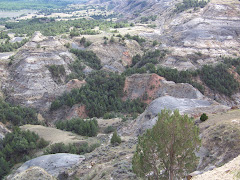
THEODORE ROOSEVELT NATIONAL PARK, NORTH DAKOTA
THEODORE ROOSEVELT NATIONAL PARK, NORTH UNIT
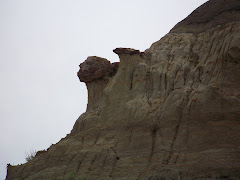
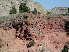
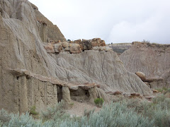
About 60 million years ago, streams carried eroded materials eastward from the young Rocky Mountains and deposited them on a vast lowland—today’s Great Plains. During the warm, rainy periods that followed, dense vegetation grew, fell into swampy areas, and was later buried by new layers of sediments. Eventually this plant material turned into lignite coal. Some plantlife became petrified. Today considerable amounts of petrified wood are exposed in the badlands. Bentonite, the blue-gray layer of clay, may be traced to ash form ancient volcanoes far to the west. But even as sediments were being deposited, streams were starting to cut down through the soft strata and to sculpt the infinite variety of buttes, tablelands, and valleys that make up the badlands we know today.
We drove the 14 mile road through the park stopping at many points along the way. We took a nature trail for .8 miles which pointed out and explained many of the different features of the badlands. We saw a herd of buffalo move into the river below an overlook. We also saw 2 mule deer, 1 white tail deer, and one wild turkey.
We took 5 hours to drive through the North Unit and we saw some spectacular sites.
SOUTH UNIT
On Friday we moved our camp to the southern unit of Theodore Roosevelt National Park. We got a nice site and then took a tour of this end of the park. The loop road was 36 miles long and we saw many of the same things as we did in the north unit.
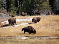
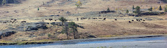
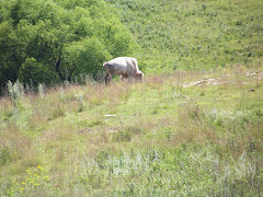
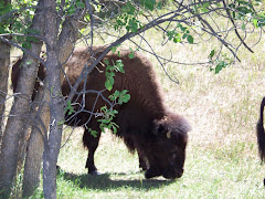
This unit is much more popular than the north. In the north unit there were probably not more than 10 cars as we passed through. The south unit, however, was very busy. As we entered the park to go to our campground we had to stop for a herd of buffalo to cross the street. They stopped right in the middle of the road and we had to sit. Needless to say, I got great pictures!
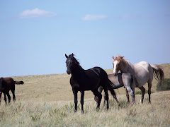
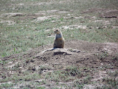
During our tour we saw several wild horses, and many, many prairie dogs that you could hear “barking”.
When we went to bed at night we saw the buffalo passing about 25 feet from the camper. They came right into the campground and passed through it to get water. I couldn’t get any pictures because Steve wouldn’t let me get out of the camper…
All in all Theodore Roosevelt National Park was the most interesting place to visit to experience the badlands and all their creatures.
About 60 million years ago, streams carried eroded materials eastward from the young Rocky Mountains and deposited them on a vast lowland—today’s Great Plains. During the warm, rainy periods that followed, dense vegetation grew, fell into swampy areas, and was later buried by new layers of sediments. Eventually this plant material turned into lignite coal. Some plantlife became petrified. Today considerable amounts of petrified wood are exposed in the badlands. Bentonite, the blue-gray layer of clay, may be traced to ash form ancient volcanoes far to the west. But even as sediments were being deposited, streams were starting to cut down through the soft strata and to sculpt the infinite variety of buttes, tablelands, and valleys that make up the badlands we know today.
We drove the 14 mile road through the park stopping at many points along the way. We took a nature trail for .8 miles which pointed out and explained many of the different features of the badlands. We saw a herd of buffalo move into the river below an overlook. We also saw 2 mule deer, 1 white tail deer, and one wild turkey.
We took 5 hours to drive through the North Unit and we saw some spectacular sites.
SOUTH UNIT
On Friday we moved our camp to the southern unit of Theodore Roosevelt National Park. We got a nice site and then took a tour of this end of the park. The loop road was 36 miles long and we saw many of the same things as we did in the north unit.
This unit is much more popular than the north. In the north unit there were probably not more than 10 cars as we passed through. The south unit, however, was very busy. As we entered the park to go to our campground we had to stop for a herd of buffalo to cross the street. They stopped right in the middle of the road and we had to sit. Needless to say, I got great pictures!
During our tour we saw several wild horses, and many, many prairie dogs that you could hear “barking”.
When we went to bed at night we saw the buffalo passing about 25 feet from the camper. They came right into the campground and passed through it to get water. I couldn’t get any pictures because Steve wouldn’t let me get out of the camper…
All in all Theodore Roosevelt National Park was the most interesting place to visit to experience the badlands and all their creatures.
LITTLE MISSOUI STATE PARK, NORTH DAKOTA
8/13-15
Little Missouri is located 19 miles north of Killdeer, ND. The camp ground caters to horse riders. The park has corrals for horses and places to park the horse trailer/camper. We were the only regular campers, and there were two ladies (twin sisters) who had each their own mule who were staying there. They rode their mules twice a day.
The campground had four horses that roamed freely all the time. We looked outside the camper and watched them. There were also 4 rabbits in the early morning and evening.
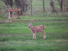
In the early evening across the badlands from our campground, we watched mule deer graze. This species of deer have long ears and very large antlers. The first evening we watched 3 males graze. What a beautiful sight!
One night you could hear the coyotes howl. What a sound! Steve also heard a bobcat catch something. He said the screaming was eerie.
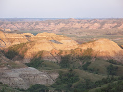
Little Missouri Park is in the Badlands of North Dakota. Badlands, what are they? Here’s what some say:
The Badlands...some call it "The Land God Forgot", others call it one of the most mysterious and beautiful places on Earth, still others liken its rugged terrain and awe inspiring rock formations to a lunar landscape. No matter what one sees in the Badlands, one thing is for certain...
"This broken country has been called always, by Indians, French voyagers, and American trappers alike, the Bad Lands." - Theodore Roosevelt
The Badlands is a region in the USA that includes western South Dakota and North Dakota marked by rugged terrain and formations that resemble a science fiction landscape of another world. These rock formations take on the shapes of domes, twisted canyons and slanted walls, often striped in different colors.
It is the most fascinating landscape so far. On Thursday we went to Theodore Roosevelt National Park, North Unit, for the day. More to come on that.
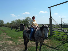
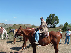
On Friday we took a trail ride into the Badlands from our campground. We were gone for two and a half hours. There was a guide, Lynelle who was 73 years old, and 6 other people on our ride. I rode Banda and Steve rode Peaches. The horses were very familiar with the trails, so we could really enjoy the view. We went on a medium trail which took us on the edge of cliffs and down steep hills. What an experience!
Little Missouri is located 19 miles north of Killdeer, ND. The camp ground caters to horse riders. The park has corrals for horses and places to park the horse trailer/camper. We were the only regular campers, and there were two ladies (twin sisters) who had each their own mule who were staying there. They rode their mules twice a day.
The campground had four horses that roamed freely all the time. We looked outside the camper and watched them. There were also 4 rabbits in the early morning and evening.
In the early evening across the badlands from our campground, we watched mule deer graze. This species of deer have long ears and very large antlers. The first evening we watched 3 males graze. What a beautiful sight!
One night you could hear the coyotes howl. What a sound! Steve also heard a bobcat catch something. He said the screaming was eerie.
Little Missouri Park is in the Badlands of North Dakota. Badlands, what are they? Here’s what some say:
The Badlands...some call it "The Land God Forgot", others call it one of the most mysterious and beautiful places on Earth, still others liken its rugged terrain and awe inspiring rock formations to a lunar landscape. No matter what one sees in the Badlands, one thing is for certain...
"This broken country has been called always, by Indians, French voyagers, and American trappers alike, the Bad Lands." - Theodore Roosevelt
The Badlands is a region in the USA that includes western South Dakota and North Dakota marked by rugged terrain and formations that resemble a science fiction landscape of another world. These rock formations take on the shapes of domes, twisted canyons and slanted walls, often striped in different colors.
It is the most fascinating landscape so far. On Thursday we went to Theodore Roosevelt National Park, North Unit, for the day. More to come on that.
On Friday we took a trail ride into the Badlands from our campground. We were gone for two and a half hours. There was a guide, Lynelle who was 73 years old, and 6 other people on our ride. I rode Banda and Steve rode Peaches. The horses were very familiar with the trails, so we could really enjoy the view. We went on a medium trail which took us on the edge of cliffs and down steep hills. What an experience!
SUNFLOWERS
One of the crops of North Dakota is sunflowers. As you drive along you see ahead of you field of yellow. They are so beautiful with their heads turned towards the sun. You can see miles and miles of them.
FORT ABRAHAM LINCOLN SP, MANDAN, ND
8/12
On the way to our this park we stopped in Jamestown, ND to see a herd of buffalo. They also have an albino buffalo named White Cloud considered to be sacred creatures by many Native American people. To some, they are a symbol of peace, unity and hope. To others, they are a sign of great changes in the world. To all, they are a blessing.
“For it was the White Buffalo Cow Woman who, in the beginning, brought to us our most sacred pipe, and from that time we have been relatives with the four-leggeds and all that amoves. Tatanka, the buffalo, is the closest four-legged relative that we have, and they live as a people, as we do.”—Black Elk, The Sacred Pipe, 1953.
White Cloud also has an albina baby, Dakota Miracle, born in the spring of 2007. We saw the herd at the Buffalo Museum.
Ft. Abe Lincoln State Park is a great place. Once again there were not many campers there and the campground was nice.
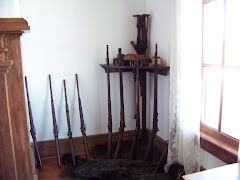
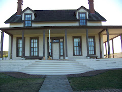
Fort Abraham Lincoln was once an important infantry and cavalry post. It was from this fort that Lt. Col. George Armstrong Custer and the Seventh Cavalry rode on their ill-fated expedition against the Sioux at the Little Big Horn. We toured the house where he lived with Mrs. Colonel Custer. The original house burned down not long after the Custers moved in and this house was built. Mrs. Custer made some changes from the original house. Apparently she was a little stuffy. She had her curtains from back home sent out to this house. She would talk to visitors at length about her curtains.
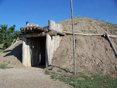
There is also a reconstructed Mandan Indian village. The earthlodges show the lifestyle of the Mandan Indians who occupied this site from about 1575-1781, The village is called On-A-Slant Indian Village. It was built on the bank of the Missouri River.
On the way to our this park we stopped in Jamestown, ND to see a herd of buffalo. They also have an albino buffalo named White Cloud considered to be sacred creatures by many Native American people. To some, they are a symbol of peace, unity and hope. To others, they are a sign of great changes in the world. To all, they are a blessing.
“For it was the White Buffalo Cow Woman who, in the beginning, brought to us our most sacred pipe, and from that time we have been relatives with the four-leggeds and all that amoves. Tatanka, the buffalo, is the closest four-legged relative that we have, and they live as a people, as we do.”—Black Elk, The Sacred Pipe, 1953.
White Cloud also has an albina baby, Dakota Miracle, born in the spring of 2007. We saw the herd at the Buffalo Museum.
Ft. Abe Lincoln State Park is a great place. Once again there were not many campers there and the campground was nice.
Fort Abraham Lincoln was once an important infantry and cavalry post. It was from this fort that Lt. Col. George Armstrong Custer and the Seventh Cavalry rode on their ill-fated expedition against the Sioux at the Little Big Horn. We toured the house where he lived with Mrs. Colonel Custer. The original house burned down not long after the Custers moved in and this house was built. Mrs. Custer made some changes from the original house. Apparently she was a little stuffy. She had her curtains from back home sent out to this house. She would talk to visitors at length about her curtains.
There is also a reconstructed Mandan Indian village. The earthlodges show the lifestyle of the Mandan Indians who occupied this site from about 1575-1781, The village is called On-A-Slant Indian Village. It was built on the bank of the Missouri River.
FORT RANSOM, ND
8/10-11
We arrived at Fort Ransom on Sunday. We used the GPS to get us there and it took us over 7 miles of gravel road to the state park. It was exciting to say the least. We did not meet any cars on the way, thank goodness, because the road was not very wide. This road is listed as an “American ByWay”. It really was nice. We stopped at a little cabin we saw on the way to the park. It was Slattum’s Cabin. As we were walking to the cabin to read the interpretive sign, a gentleman drove up and asked if we wanted to go inside. This man was the great grandson of Mr. Slattum who built the cabin. It was very small as you can see from the picture. Mr. Slattum came from Norway and he and his wife raised 9 children in this small cabin. He walked from south Minnesota to settle in this region of North Dakota.
Next on to Fort Ransom and a gorgeous camp site. There were only 6 other campers in the park.
We took a ride to the overlook and looked at the area. It was awesome. The sign gave an explanation of how North Dakota was formed. Eastern North Dakota was covered by the Western Interior Seaway between 60 and 90 million years ago. This warm subtropical sea was less than 500 feet deep and stretched from the Arctic Ocean to the Gulf of Mexico. There are many fossils found in the area. Three layers of rock (called formations) extend over eastern North Dakota. These formations, which began as sediments washed into the sea, were deposited along the shoreline on the seashore.
Sandstone was deposited along the fluctuating shoreline, with shale and limestone forming on the bottom in deeper waters.
It rained all day Monday. This was the first day since we left from Kate’s on July 7th that we really couldn’t do anything. It was a good day to catch up on rest, reading, and a couple of videos.
BUFFALO RIVER SP, GLYNDON, MN
8/8-8/9
While driving to the park today we went through Frazee, MN and saw where your Thanksgiving turkeys come from. There were many large barns full of turkeys!
This park has one of Minnesota’s finest and largest remnant prairies. We took a 3 mile hike around the prairie. It was beautiful with many different kinds of trees, plants, and flowers. We saw three large birds that we were unable to identify; however, they live in the moist shady grass and fly really fast when you walk by.
After our hike we drove into Fargo, North Dakota to get some information on the next leg of our trip. We collected lots of information on things to see and do in North Dakota. We then went to a great restaurant, DooLittles, which had wood grilled chicken. It was delicious.
This park also has a pond that they keep clear with chlorine. They pump water in from the Buffalo River and then treat it and fill the pond. This is a very busy place on the weekends as the people in the area come for picnics and swimming.
Friday night we went to the Minnesota State University Science Center to look at the stars. They were supposed to have telescopes for everyone to look at, but the sky was overcast and we couldn’t see any stars. There was a power point presentation about the sun, planets, meteors, and comets. It was very interesting.
CROW WING SP, BRAINERD, MN
8/6-8/7
We arrived at Crow Wing State Park on Wednesday August 6th. We set up camp and then took a bike ride around the park. Our first stop was the Mississippi River. What a beautiful sight. We hiked to Chippewa Lookout for a view of the Misssippi from 400 ft above sea level. Then we continued around to see The Catholic Mission, where the Knights of Columbus rebuilt the mission; and the Lutheran Mission which had a plaque about the area.
“There is some disagreement about the origin of the name Crow Wing. Most agree that the 19th century town, the county and the state park honored the name of the river. Some claim that the river was so named because an island, prominently located at the confluence of the Mississippi and Crow Wing Rivers, is shaped like a crow's wing. Others claim that the name is a mistranslation of an Ojibwe word for raven or raven feather. Still others say that the name is derived from the Little Crow chiefdom and lineage of the Dakota, who inhabited this region before the Ojibwe. According to historian William Warren, this was the scene of a major battle between the Dakota and Ojibwe Indians in 1768. The fur trade era brought the voyageurs of the Northwest and American Fur Companies. Soon traders established posts along the rivers and a branch of the Red River Trail brought ox carts through the area. Leaders of the territory and the state settled here. Allen Morrison, the first citizen of Crow Wing, established a post below the southern mouth of the Crow Wing River in 1823. In 1847, Clement H. Beaulieu took over operations of the American Fur Company at Crow Wing and built a stately mansion in the frontier village. This Greek Revival structure survived the ages. It has recently been returned to its original location and is presently being restored. Missionaries came to teach the Indians and build mission churches. The cemeteries remind us of the once thriving community.” http://www.dnr.state.mn.us/state_parks/crow_wing/narrative.html
On Thursday we kayaked the Mississippi River. It was a lot of fun. There was a good current going down the river. As usual when we kayak, on the return trip the wind and current were against us and it was quite a challenge to get back to where we put in. We had beautiful weather and wonderful time just looking and listening.
Tuesday, August 5, 2008
Chippewa Moraine
If you want to know more about the Ice Age and formation of Wisconsin go to the following website. It shows the museum we went to. Have fun!
http://www.dnr.state.wi.us/org/LAND/parks/specific/chipmoraine/
http://www.dnr.state.wi.us/org/LAND/parks/specific/chipmoraine/
Grand Island Casino RV Resort
We decided to go to Grand Casino RV Park Resort. We are in Hinckley, Minnesota, and have a nice site. The campground has 271 sites but not all are filled. You can take a shuttle to the casino next door from your campsite. You just put the red flag down. The shuttle runs 24 hours a day because the casino is opened for 24 hours. We went Monday evening and played slots for about 2 ½ hours. We came out about $18.00 ahead.
Today, Tuesday, we worked on planning our trip since we have internet. We have made some reservations because we have discovered some of the places we want to visit have few openings. Also, the retired Steve forgot that the first weekend in September was Labor Day weekend.
We went over to the casino to play some more slots and have a buffet lunch in the Grand Casino Restaurant. It was a delicious lunch and we had a fun time with the machines. We came out about $2.00 ahead for the two days.
We are sitting in the laundry right now catching up on dirty clothes. We were going to swim in the pool right outside the laundry, but some child had an accident in the pool so it is closed…
We will leave on Wednesday morning and go to Brainerd, Minnesota, to Crow Wing State Park. This is a flyway for birds. We will also get to kayak on the Mississippi River.
Chippewa Moraine Unit--Ice Trail
On Monday we left Brunet and headed west to Minnesota. On the way out of Wisconsin we went to Chippewa Moraine Unit along the Ice Age Trail. There we visited an interpretive center that provided a unique glimpse into Wisconsin’s glacial past. It is one of the 9 units of the “Ice Age National Scientific Reserve Park”. It is amazing how the Wisconsin terrain was formed from glaciers.
Brunet Island State Park, Cornell, Wisconsin
We reached Wisconsin on Wednesday July 30th. We stayed at Hiawatha RV Resort for one night. It was a great campground. We had chance to get the laundry done.
On Thursday we went to Brunet Island State Park in Cornell, Wisconsin. The landscape in Chippewa County is a product of the most recent Ice Age (the Pliestocene Epoch). The rolling terrain carries a wide variety of forest types and is home to a multitude of wildlife. The campground has about 69 campsites. The North Campground did not have electricity but the sites were on the water. That is where we stayed. It is by far the most beautiful campsite on our trip. The site was large and private. We enjoyed watching Eastern Kingfishers “hawk” for bugs. They would dive down to the water and get a bug and return to a tree or bush.
We also saw a pileated woodpecker which is the largest of all woodpeckers.
I was not able to take a picture because my camera was broken. I have since bought a new one and now I am back in business.
On Friday we kayaked around the island. It took us three hours. We always take our time and go into the coves. We started out on the Chippewa River and went into the Fisher River. On the way out of one of the coves we saw an otter swimming around.
On Saturday we took a 40-mile round trip bicycle ride on the Old Abe State Recreation Trail. It begins in Brunet Island State Park and goes to Lake Wissota State Park. The trail was an old railroad track that was taken out of service and paved. We had a great time, but we were very tired. It took approximately 7 hours to go down, eat a picnic at Lake Wissota, and then bike back.
On Sunday the weather was a little overcast, and so we went about 39 miles south to Eau Claire, Wisconsin, to get a new camera. This time we drove the truck.
Thursday, July 31, 2008
Woodruff, Wisconsin
Well today Wednesday July 30th we left Michigan, but now before stopping at the Kewadin Casino in Christmas, Michigan. We took in $20.00 each and came out with $0.00 each. What a great land that you can go to the casino at 9:00 a.m. on your way to your next stop.
We stopped in Marquette, Michigan and visited Wal-Mart for a few supplies. We arrived in Woodruff after 226 miles of driving and entering the Central Time Zone. We are at this nice campground with wifi and electricity.
We leave on Thursday to go to Brunet State Park. We probably will be without services again.
Until next time.....
Wednesday, July 30, 2008
Pickle House Grand Marais Michigan
The Pioneer Cooperage Co. of Chicago designed this vacation cottage in 1926 build for William Donahey creator of “The Teanie Weinies”. The main barrel consisted of a living area on the first floor and bedroom on the second. The smaller barrel is the kitchen. Donahey spent 10 summers at the cottage with his wife Mary. The Pickle Barrel House is listed in the National Register of Historic places
Pictured Rocks Lakeshore
On Tuesday evening July 29th, we took a sunset cruise on Lake Superior to see the Pictured Rocks. It was so beautiful.
The brochure gives the following information about Pictured Rocks: “Massive glaciers inched back and forth across this land for a million years, scouring and molding, while the land yielded and took on a new shape. Moving ice ground the volcanic and sedimentary rock of previous eras into rubble and slowly enlarged river valleys into the wide basins that would become the Great Lakes. The last glacier began its retreat about 10,000 years ago. Overt time meltwater from this wasting glacier formed powerful rivers and scattered rubble onto outwash plain and into crevasses. The water scooped out basins and channels hat harbor the wetlands found in the park today. Eventually, as the weight of the glacier lessened, the land rose and exposed bedrock to lake erosion. It was this onslaught by the lake-centuries of battering waves and ice—that carved the bedrock into young cliffs. Relentlessly the water continues to pound and sculpt the cliffs, eroding them inland while enlarging the lake.
Solid or liquid, the force of the water profoundly altered the landscape an created the largest freshwater lake system in the world. The name “pictured rocks” comes from the streaks of mineral stain that decorate the face of the sculpted cliffs. The Munising Formation makes up much of the angled slope and formations, such as Miner’s Castle. Covering all is the 400 million-year-old Ordovician Au Train Formation, a harder limy sandstone that serves as capstone and protects the underlying sandstone from rapid erosion. The streaks on the cliffs occur when groundwater oozes out of cracks. The dripping water contains iron, manganese, limonite, copper, and other minerals that leave behind a color stain as water trickles down the cliff face.
Au Sable Point Lighthouse
The Au Sable Light Station is located on Au Sable Point, originally called Point Aux Sables by the French, who named it for the nearby Grande Sable Dunes.
At least as early as 1622, when Pierre Esprit Radisson called it “most dangerous when there is any storms, Au Sable Point was recognized as a hazard to Lake Superior mariners. When lake traffic began to boom in the middle nineteenth century with the opinion of the Soo Canal (1855) the reef at Au Sable Point was particularly dangerous. Unless warned off, vessels could become victim to this reef of Jacobsville Sandstone which, in some places, lies only a few feet below the surface.
Mary Jarecki—the first wreck east of Twelvemile Beach is this wooden bulk freight streamer, victim of a July 4, 1883, stranding. The ship, heavily laden with iron ore, ran off its course and ground ashore in fog off the mouth of Hurricane River. Today, the remains may still be seen resting on the bare sandstone bottom just outside the breakers near the lighthouse. The long oak keelsons, studded with iron treenails, are just above water. No lives were lost in the incident.
Hurricane River National Forest Campground in Picture Rock Lakeshore
We left Tahquamenon Falls State Park on Monday July 28th and headed west. We decided to take a road to the north and landed up in Pictured Rocks Lakeshore. This is a national park. We went to the visitor’s center and discovered that there are many campsites you can go to along this coast. We drove about 7 miles, 1 of which was dirt, and stopped at Hurricane River Camping. There are only 11 sites here but we were lucky to get a spot.
While we were at the visitor’s center, Dad got a Senior pass that lets us camp at National Parks and Forests for half price. We paid $7.00 for tonight. There are pit toilets and a water spigot. We then took about a 2 miles walk to the Au Sable Light House. It was beautiful. We walked back along Lake Superior. The water was beautiful as were the rocks.
We also saw remains of a shipwreck. The Mary Jarecki was the first wreck east of Twelvemile Beach. The ship, heavily laden with iron ore, ran off its course and ground ashore in a fog off the mouth of Hurricane River. This happened on July 4, 1883. The remains can still be seen resting on the bare sandstone bottom just outside the breakers near the trail we took to the lighthouse. The long oak keelsons, studded with iron treenails, are just above water. No lives were lost in the incident.
Kayaking on Tahquamenon and talking with a "Yooper" about living and snowmobiling on the Upper Peninsula
On our way home we went on an access road to Tahquamenon Bay. We had to go down a dirt road. It was so beautiful. We decided to go kayaking. We went down the bay and headed towards Emerson Island where there was a logging mill many years ago. You can see the wooded posts still in the water. The water was not very deep. We continued on down the bay. It was so quiet and peaceful. We decided to turn around and head back and the wind came up. It was very difficult to paddle back but we had to keep going. The water was so shallow that at one point I had to get out of the kayak and push it into deeper water. I was so exhausted by the time we got back to the truck. We were starting to load the kayaks when a gentleman, Mike, came to let his dog swim in the bay. We talked with him for awhile. He gave us some great insight into the life on the upper peninsula in the winter. His home is 7 miles from the main road and in the winter they have to take snowmobiles to the main road in order to get to work. His daughter takes the snowmobile to the main road and then gets the school bus. He belongs to a snowmobile club and they groom about 110 miles of snowmobile routes in the winter.
Tahquamenon Falls State Park has its own brewery and it is opened all year long. His snowmobiles club goes there quite often to meet other clubs. In the winter he says you can see about 30 cars and 300 snowmobiles at the restaurant.
Tahquamenon Falls State Park has its own brewery and it is opened all year long. His snowmobiles club goes there quite often to meet other clubs. In the winter he says you can see about 30 cars and 300 snowmobiles at the restaurant.
Cenennial Cranberry Farm
On Monday we went to the Cranberry Capital of Michigan. We went to a cranberry bog. I don’t believe it has been in harvest for awhile; however, we got to see the equipment they use and watched a video. It costs $5.00 each to go through on a self-guided tour. Dad bought some cranberry syrup and some cranberry sauce. He had the syrup on pancakes on Monday morning.
Cranberries are harvested in late fall. The cranberry bogs are flooded and then they use a machine that vibrates the berries off the plants and then they usea boomboard and boom them together. They are then put on a conveyor belt to get them out of the bog.
Centennial Cranberry Farm has a water reel beater that was constructed by a talented neighbor. The berries they harvest for juice and sauce are sold to Cliffstar Crporation of Dunkirk, New York. Cliffstar is the largest private label processor in this country and processes cranberry, grape and apple juice for Walmart, Sam's brand.
The Centennial Cranberry Farm was purchased by John Clarke from the U.S. Government in 1876 and has been in the same famiy for 130 years.
Great Lakes Shipwreck Museum, Whitefish Bay
We also visited the oldest working lighthouse on Lake Superior—Whitefish Point Lighthouse. In 1861 President Abraham Lincoln had the lighthouse keeper’s quarters built. The lens had to be rewound every 2 ½ hours and therefore had to have two lighthouse keepers. The quarters housed the families of the lighthouse keeper and lighthouse keeper’s assistant. It was a very lonely life but these men were dedicated to their job. The woodwork and hard wood floors in the quarters are original from 1861. We also went into the Life Saving Service building which houses a replica of a rescue boat. There were 8 men who would take this boat and rescue the people from the ships at sea.
What an awesome place. The museum had stories and artifacts from many shipwrecks that have occurred on Lake Superior. The most famous being the Edmund Fitzgerald in 1975. We also watched a video on the Edmund Fitzgerald and its 17 year history carrying iron ore and steel across Lake Superior.
What an awesome place. The museum had stories and artifacts from many shipwrecks that have occurred on Lake Superior. The most famous being the Edmund Fitzgerald in 1975. We also watched a video on the Edmund Fitzgerald and its 17 year history carrying iron ore and steel across Lake Superior.
Tahquamenon State Park, Upper Peninsula, Michigan
Friday July 24th
We left the KOA in Newberry, Michigan and drove 36 miles north to Tahquamenon (pronounced like phenomenon) State Park. What a beautiful place. We have a corner campsite that is large and comfortable.
Today, Saturday July 25th we visited the upper and lower falls of the Tahquamenon River. The brochure for the state park says, “Rising from springs north of McMillan and drains the watershed of an area of more than 790 square miles. From its source, it meanders 94 miles before emptying into Whitefish Bay. The amber color of the water is not rust nor is it muddiness; it is caused by tannin leached from the Cedar, Spruce, and Hemlock in the swamps drained by the river. The extremely soft water churned by the action of the falls causes the large amounts of foam, which has been the trademark of the Tahquamenon since the days of the voyagers.”
Thursday, July 24, 2008
Mackinac Island
Today we visited Mackinac Island. We drove about 60 miles south to St. Ignace to the ferry. We took our bikes with us and boarded Shepler's Ferry Service to the Island. It was a 16 minute ride. The view was breathtaking and the weather was sunny and beautiful. Once we arrived at the island, we got on our bikes and began the shore ride along the coast. You could see different shades of blue in the water depending where you were.
There are no automobiles on Mackinac Island. They have been forbidden since 1898. People get around by bicycles, horse drawn wagons, and foot. You can rent a horse and buggy if you choose. They have bikes for rent, and you can take a taxi which his a horse and wagon.
We stopped at many interesting points along the way. For instance we stopped and climbed the stairs to Arch Rock. It towers 146 feet above the road. The Arch rock is a perforated breccia mass. The Arch Rock formation is one of the natural wonders of the Midwest.
We rode about 2 miles and then stopped and had peanut butter and crackers along the shore. Then continued another 2 miles and then turned on the British Landing Road. When the War of 1812 broke out the British landed secretly on the island. The Americans surrendered to the British.
We also visited a Butterfly House. You walked into this glass room and there were plants from all over the world. The butterflies comes from the Rain Forest in South America. Music (Kenny G) was playing as you walked around and saw all the different kinds of butterflies. It was a truly relaxing time.
After we went to St. Anne's Church. It was started by the Jesuits who came to convert the Native Americans.
We then had lunch at the Yankee Rebel Tavern.
Tuesday, July 22, 2008
A Bear of a Travel Day
Today was a travel day as we departed Canada for the Upper Peninsula. Most of the 100 or so miles in Canada we skirted Lake Huron or drove directly beside the beautiful Mississagi River. As you can see from the photo, traffic was a bear. Speaking of bears, a Black bear ran across the road in front of us this morning. I do not know if bears gallop but I would say he was moving right along. We entered the US after customs made a cursory search of our camper. We arrived at the Newberry (MI) KOA and will use this as a base for sightseeing over the next couple of days.
Monday, July 21, 2008
Kayacking the Serpent
Steve and I kayaked the Serpent River from just above the Spragge KOA boat launch down into the North Channel. Steve says the North Channel is part of Lake Huron so technically we kayaked on a Great Lake. To date we have kayaked a large inland lake, a river, and a swimming pool. The latter was a lot warmer but no where near as much fun. Tomorrow it's on to Michigan.
Change of Plans
We arrived at Mississagi Provincial Park around 4 p.m. and could not get our camper on a site. The land was sloping too much to be able to level. So we pulled out the maps and Good Sam Travel Guide and found a KOA in Spragge, Ontario, on the Serpent River.
We have been doing laundry and blogging to keep current. We are going to kayak this afternoon on the Serpent River which goes into the North Channel and into Lake Huron.
We have been doing laundry and blogging to keep current. We are going to kayak this afternoon on the Serpent River which goes into the North Channel and into Lake Huron.
Sunday, July 20, 2008
TRAVELING TO MISSISSAGI PROVINCIAL PARK
We left the park at 8:15 this morning and drove into North Bay to use their dump station at the Information Center. We are sitting here updating our blog. We think of you all often and wish you could see this beautiful country. We will add to our blog later.
Love to you all and talk to you soon.
Love to you all and talk to you soon.
ALGONQUIN PROVINCIAL PARK
We arrived at Algonquin Provincial Park around 4. We left Ottawa at 9:00 a.m. It was a long but beautiful ride. Some of the trans Canada highway, Route 417 changing to 17, was a lot bumpy. Some of the clothes hanging in the closet fell out.
We got site 7 which is the most beautiful site I think we have ever had. We are less than forty feet from the lake. The name of the lake is Kioshkokwi (Kiosk for short). The wind was blowing quite hard here so we did not put up the canopy. On Monday the wind was strong with almost one foot high waves. We took the Kayaks out to do a little fishing. We had to keep paddling back out because the waves brought us into shore. On Tuesday we left at 7:30 a.m. on calm waters and kayaked 6 km to the west side of the lake. It took us almost 2 hours. While we were kayaking into a cove that had a large marsh, we saw two moose come out of the woods. There was a mother and a baby (this was a large baby). We paddled closer and just watched them. The mother never took her eyes off of us. It was amazing! We stayed for a little while and then the mother and baby just strolled back into the woods.
There was also a loon on the lake. I don’t know if the older boys remember when we went camping on Conway, NH. We could here and see the loons on Conway Lake. Loons can swim under the water for a very long time. You see them and then they dive and then you have to watch for quite a while and you will see them come up far away.
As we left the cove and continued across the lake we saw two more moose. Another mother and a smaller baby. They watch us for a few minutes and then went back into the woods. We were gone for five hours that day.
On Tuesday the water pump began to act up. The water pressure was very low and the pump made a terrible sound. On Wednesday Steve checked it out and found the pump was leaking. We checked with the office here and the lady let Steve call an RV dealer and they had one in stock. Steve wanted to buy a repair kit and the guy said these pumps are throw and go. This means for $118.00 you buy a new one. We drove into North Bay, Ontario, about 90 km from here. When we got back he put it in and as with pretty much everything in this camper, the pump works better than the original one. Now we had enough water pressure to take a shower.
On Thursday we went out in our kayaks on the lake again and went 4 km in the other direction. We took our time and were gone 5 ½ hours this time. We did a lot of fishing and Steve caught two small mouth bass. One was about 2 pounds and the other was 11/2 pounds. They put up a good fight. His rod was really bent over. I caught a lake trout that was about 14 inches long. It was a successful day fishing.
OTTAWA, ONTARIO
On Thursday July 10th we left Vermont and entered Canada in Cornwall. We drove through upper New York State and crossed the border into Canada. The border guard was very friendly. He asked if we knew anyone in Canada and we said, “No.” He was surprised.
We stopped at a gas station to change some of our money into Canadian dollars. $200 Canadian dollars cost us $222.00 American. We are not sure what a bank exchange rate is but when we stopped in New York at a Citizens Bank, they did not exchange and sent us to the gas station.
From Cornwall we drove to Ottawa. The trans Canada highway is beautiful. The speed limit is 90 kph (55) which is our favorite speed to drive. I drove from Vermont to Ottawa. We arrived at the Ottawa Municipal Campground. What a nice place. We had electric and water and got spoiled for three days. On Friday we went into Ottawa for the day. The Bytown Trolley company sent a trolley to the campground and picked us up and one other family. We left the campground at 8:45 a.m. It was a 30 minute ride into downtown. When we arrived we bought a trolley ticket for a one hour tour of the city and then drop off and get on around the city.
Before we took the one hour tour we went directly to Parliamentary Hill for the changing of the guard. We got there early and were able to get a great spot to view the ceremony. It was very impressive. There was a band, Scottish bagpipe players, and three companies of soldiers. The ceremony took 30 minutes and the music was awesome. After the ceremony we took a self guided tour around the grounds of the Parliament. We learned a lot about how Canada was formed. I don’t know about any of you reading this, but I was a little lacking in Canadian history.
The weather was beautiful for touring. We stopped at a deli to get a sandwich and then sat outside to eat. Sparks Street is a pedestrian mall. It covers 4 blocks and there are no cars allowed. Also if you ride your bicycle through this mall you can be fined $53.67.
We then took the one hour trolley tour and even went across the Ottawa River into Gatineau, Quebec. There were many interesting sites, but one that impressed us was the Notre Dame Cathedral Basilica. The construction began in 1827. Inside was so beautiful.
We then went back to Parliament Hill and went up in the Peace Tower. You can look out over the entire city of Ottawa. This tower was built from 1919 to 1927 and was dedicated to the more than 60,000 Canadian soldiers who gave their lives on the battlefields of Europe during the First World War standing 92.2 meters (302 feet, 6 inches) tall. The Pease Tower is a campanile: a free-standing bell tower. It houses the carillon, a set of bells sounded from a keyboard. There are 53 bells in the Peace Tower. The largest is called the “bourdon” and weighs in at 10,160 kilograms (22,000 pounds)—that’s roughly the weight of three adult elephants! The smallest bell weights 4.5 kilograms (10 pounds).
On Saturday we had to go grocery shopping. I wanted some beer and they do not sell any liquor, beer, or wine in a grocery store. As we were driving around we found The Beer Store. This is where you buy your beer. We shopped at Loblaws which was a super grocery store. Things cost so much more in Canada.
We left Ottawa in Sunday July 13th. It was over two hundred miles to Algonquin Provincial Park where we were headed for the next week. We stopped at a dairy bar called Laurentian View Dairy in Deep River Ontario. Steve had a breakfast meal and I had soup and a open-faced sandwich. It was scrumptious! Of course we had to try their ice cream and it was delicious. I had orange ice cream with a chocolate ribbon and Steve had Boston Crème.
MORE NORTH HERO STATE PARK VERMONT
The following is from the brochure put out by the Isle La Motte Preservation Trust: “The Isle La Motte in Vermont has an ancient reef believed to be almost half a billion years old. It is the world’s oldest reef in which corals first appear. The Isle La Motte is home to the most complete fossil record of the Chazy Reef. This reef began taking shape 480 million years ago at te bottom of a warm shallow sea south of the earth’s equator during what geologists all the Ordovician Period. Over a period of 10 million years, the reef grew from the calcium carbonate remains of he creatures in this ecosystem. Though the reef once stretched a thousand miles along the proto North American continent, most of it has disappeared or been destroyed by mountain building and other geologic forces. Only a few remnants of the great reef remain.”
We went to the Goodsell Ridge, the most famous reef site on Isle La Motte
We went to the Goodsell Ridge, the most famous reef site on Isle La Motte
Saturday, July 12, 2008
North Hero State Park, Vermont
We arrived at North Hero State Park in Vermont on Monday July 7, 2008. It was terribly muggy about 88 degrees and enough mosquitoes to carry one adult off. We coated up with OFF and set up camp. We had a beautiful secluded site. The park was barely one third full.
We tried out our Kayaks and they work great! We are getting better at taking them off and getting them back on. Lake Champlain is a beautiful lake. We stayed around the beach as we wanted to become familiar with them.
We rode our bicycles on Tuesday for about 10 miles. It was mostly along the Lake and what a gorgoeus site. We kayaked again on Wednesday. It was fun. The lake was a little choppy so we had to make sure we didn't get water in the kayaks. It was so cool!
Wednesday we went in to Isle de la Motte and visited the Shrine of St. Anne (the mother of Mary). It was beautiful. They had an outdoor Stations of the Cross with a large crucifix. This was also right on the Lake. We then took our bikes and biked to an area that had fossils from millions of years ago. Then biked back to the truck.
Thursday we packed up and left for Canada. What a great spot in Vermont if you like to camp.
Monday, July 7, 2008
Preparations
We have been gone from home for three weeks now. We stayed in Plymouth, New Hampshire, with Steve's Dad who is 94 for a week. Then we came to southern NH and attended Lily Rose's dance recital. Lily is my niece. Then we took Lily and her brother, Teddy, camping to Emerald Lake State Park in Dorset Vermont. We had a wonderful time hiking, fishing, having a campfire and just being together. The children love to play SORRY!
On Sunday June 29th a microburst came to Kate's and took our canopy and turned it over on top of our camper. We spent the next few days calling the insurance company and a camper place to get it fixed. Thanks to State Farm's fast work we got a brand new canopy and air vent on Thursday.
We then returned to Kate's and over the fourth of July six of the children came to visit. Our oldest son, Steve, got engaged on July 4th to Nicole. We are very happy. Nicole is a wonderful girl and she will make Steve a great wife. Welcome to the family, Nicole.
We also celebrated our second granddaughter, Gabriel's, first birthday. She is adorable and her sister, Elise, is also adorable. It was great to spend time with them.
We will miss everyone while we are gone, but you will all be in our thoughts as we travel around the country.
Sunday, July 6, 2008
Leaving for Vermont, the first leg of our adventure
July 7,2008
Here we are leaving my sister Kate's house in Windham, New Hampshire.
Here we are leaving my sister Kate's house in Windham, New Hampshire.
Subscribe to:
Posts (Atom)